SPOT 5 Products
A brief history of SPOT
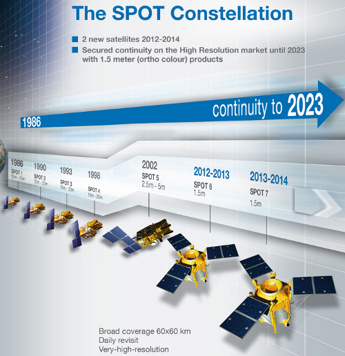
The SPOT (Systeme Pour l'Observation de la Terre or System for Earth Observation) satellites are operated by SPOT Image (created in 1982), a subsidiary of EADS Astrium and based in Toulouse, France. The program was initiated by the French space agency, CNES (Centre national d'estudes spatiales) in the 1970's in collaboration with the Belgium (SSTC) and Swedish (SNSB) science and space agencies. The first SPOT satellite was launched in February 1986. SPOT 1-3 are no longer operational. SPOT 4 acquired the last image on 11 January 2013 and is in a de-orbiting phase. SPOT 5 is fully operational and SPOT 6 was launched on 9 September 2012.

The SPOT constellation.
The SPOT 5 satellite
SPOT 5 was launched on 4 May 2002. It has a polar, circular, sun-synchronous and phased orbit with a revisit time of 26 days. SPOT 5 multi-spectral imagery is acquired by two High Resolution Geometric (HRG) cameras on board the satellite at a spatial resolution of 5m, 10m and 20m, The satellite also carries the High Resolution Stereo instrument (HRS), which acquires black and white stereo pairs at 10m across track and 5m along track, and the wide swath VEGETATION 2 instrument with a spatial resolution of 1000 m.

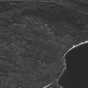
SPOT 5 Panchromatic scene (T scene).

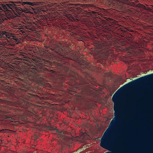
SPOT 5 multi-spectral scene (J scene).
HRG Sensor
The HRG sensor is optical. It uses the SPOT Grid Reference System (GRS) using K and J co-ordinate pairs. The scanner is push broom with a swath of 60km. There are 6 bands (2 panchromatic bands). The sensor has a spectral range of 480nm - 17 500nm. The sensor produces imagery with a size of 60 km x 60 - 80km. This sensor is taskable. The panchromatic (black and white) imagery has a resolution of 5m for each camera (A and B), which are super-sampled to 2.5m resolution (T scenes). The multispectral imagery consists of four bands in the green, red, near-infrared and shortwave infrared electromagnetic band widths and has a spatial resolution of 10m (J scenes). The shortwave infrared band is acquired at 20m but resampled to 10m. The panchromatic and multi-spectral imagery can be fused to produce a pan-sharpened multi-spectral image at a resolution of 2.5m (JT scenes).

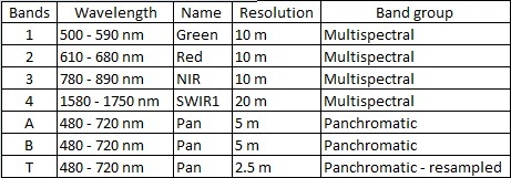
SPOT 5 band specifications
Ground segment TS5 products
Level 1A : Radiometrically corrected (recommended as an input for orthorectification).
Level 1B : Radiometrically and geometrically corrected using the predicted or definitive ephemeris if available. (recommended as an input for orthorectification).
Ephemeris : Table of values that gives the positions of astronomical objects in the sky at a given time or times.
SANSA processing levels
The panchromatic and multispectral imagery can be fused to produce a pansharpened multispectral image at a resolution of 2.5 m. Further processing of imagery includes ground control point collection, orthorectification, at sensor reflectance calculations, mosaicking, clipping and atmospheric correction.
Level 2A : Geolocated using the satellites position (import only).
Level 2B : Geolocated using Ground Control Points (auto GCP collection).
Level 3Aa : Orthorectification using GCP points, reference imagery and a 20 m DEM. Suitable for spatial analysis including digitisation (i.e. GIS and RS ready).
Level 3Ab : Reflectance values at top of atmosphere (at scanner reflectance). Suitable for visual interpretation, spectral signature analysis, classification and derivation of indices (NDVI, EVI).
Level 3B : Mosaicking of many images into a larger single image.
Level 3PS : Pan-sharpen or fusion of the multispectral with the panchromatic at the resolution of the panchromatic.
In addition to this, you may specify additional processing options when ordering SPOT 5 imagery through the SANSA Earth Observation Catalogue. These additional options are:
Clipping : Select a subset of a landsat 7 image.
Reprojection : Default projections include UTM and Geographic coordinate.
Format change : Default format are Geo TIFF (tif), JPEG2000 or PCI pix.
Useful links and technical information
Sample Imagery: SPOT 5 2.5m colour ortho (1143 mb)SPOT 1-5 technical information
About Resources
On this page you will find a variety of links with descriptions to earth observation resources, ranging from user guides, commercial catalogues to free data sources, other portals and softwares. Should you know of any other interesting links, please send them to us and we will add them to the resources webpage.


